
|
| My other photographs |
As you are reading the English version of my site, I suppose that you are not a native Russian or Ukrainian speaker. Then I should expect you to be familiar neither with Kharkov city, nor with the territory I have called ‘Kharkov region’. Well, here is some initial information for you before I start to list examples of local architectural heritage. Ukraine has inherited its administrative structure from the Soviet Union. Its territory is divided to more than twenty what I will call ‘regions’ and the Crimean autonomy republic. Each region spreads for about 150-200 kilometers (~100 miles) and the largest city in a region is its administrative center. The region is usually named after its administrative center. Each region is divided to several what I will call ‘districts’. Just like regions, districts have their administrative centers. So, now you should understand that ‘Kharkov region’ is one of the regions of Ukraine, and it its administrative center is Kharkov. And whenever I will need to indicate location more precise, I will also tell the name of the district. Now let me tell a few words about the age of the buildings having historical importance. In Kharkov region, there is no stone. We have a good deal of different soils, here and there a little bit of sandstone can be dug out, there are also a few chalk hills on the very south edge of the region, but no hard stone for hundreds of kilometers around. For thousands of years this used to be a site of many wars, and the fighting nations surely were interested in building some kinds of fortifications, but all the materials they had were soil, clay, and some wood. And they used them. Surely these fortifications have not lasted long enough to be seen now. Only outer walls of the biggest fortified settlements are visible now: Scythian, Khazarian, Slavonic, and some others. Although they are important, they are not what I am about to show you. Frankly saying, they are just too hard to photograph... In early XVIII century Kharkov was already within the Russian empire, and, decade after decade, the southern frontier was moving farther and farther to south, giving the people a more peaceful way of living. It was the time when the first brick and stone buildings were built. Naturally, they belonged either to Orthodox Church, or to some wealthy people. So, the oldest buildings that still can be seen are churches and manor houses. In a book describing the architectural heritage of Ukraine that I used to sign my photographs correctly, the main building of an estate (a manor house) is usually called a palace. I am not sure whether this term is correct in English, but still use it. During the XX century these buildings, as the whole country, were damaged several times during wars. Now that the state does not have enough money to keep them in order, the survived buildings are still in danger. It is quite possible that some of them will be lost. One of the reason I photograph them is my wish to try to document their current condition. |
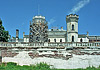 |
The manor house of the former Sharovka estate is now in Sharovka village, Bogodukhov district. It was established in the early XIX century, and then was expanded up to XX century. Now there are a landscape park, a palace, and numerous secondary buildings. In Soviet times, a sanatorium for consumptives was placed here. The estate amazes with its unusual architecture. Map of Sharovka vicinity. The approximate boundary of the landscape park surronding the palace is given with red dots. |
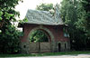 |
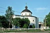
A wealthy sugar manufacturer, Ivan Kharitonenko had named his estate after his grand daughter. Now it is Vladimirovka village, Krasnokutsk district. The manor house was lost. The landscape park remained, but had not had a proper care. A remarkable church of the Savior designed by Shchusev is in good condition. The main gates of the same architect are not treated as well, but still are worth of being seen. There are also a few secondary buildings left. Map of Natalievka (Vladimirovka village) vicinity. The road bend is the boundary of the park. |
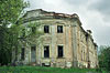 |
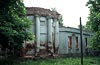
Being established in 1724 the park beside the palace is the oldest witness of the estate, although I am not sure if some trees are left since then. The palace and the secondary buildings were built in 1770-ieth. The buildings, especially the palace, are in very bad condition. Map of the Staryi Merchik village. |
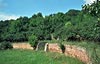 |
The terraces are in Gorodneye village, Krasnokutsk district. A more precise location is given on the map below. They are garden terraces on the sunny side of a small valley. The terraces are strengthened with brick walls. their concave shape creates a peculiar acoustic effects, which, probably, explaines why they are called ‘singing. Here and there one can find remains of some pipes, either drainage or irrigation ones, I’m not sure. To the best of my knowledge, the terraces are not officially considered to be an architectural heritage, but still they are, I believe, the only example of their kind in the Kharkov region. Map of the terraces location. |
 |
The former Giyevka village is now a part of Lubotin town. The estate belonged to prince Sviatopolk-Mirskoy. The church of St. Nicholas (3) appears to be repaired recently. The secondary building (2) was used as a club (in Soviet sense of the word) and a few years ago a fire had damaged it awfully. The palace (1) has remained but needs a repair. The estate was established in 1820-ieth, the palace was built in 1840-ieth (before that, there was another manor house). Map of the buildings locations. |
 |
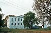
A manor house and a church of early XIX century in Rakitnoye village, Novaya Vodolaga district. The church can be found on topographic maps of the scale of 1:200,000 and larger, the palace is right behind the church. |
 |
Village Malyzhino is close to the boundary between the districts of Zolochev and of Bogodukhov, near river Merla. Most of the buildings are now within the territory of a mental house, hence visiting is complicated, if possible at all. On the other hand, those building are certainly in much better condition than the ruins of the church of the Assumption. On the photographs you can find the church and the main building of the former estate. Map of the buildings locations. |
| My other photos |